September 23-26, 2012
Recently I had an opportunity to spend some time in Seattle for a work assignment that I turned into a small vacation with my girlfriend Rachel. After sight-seeing in the city, we headed west toward the Cascade Mountains for some hiking. Together we hiked for the first two days and then after she left I hiked two more mountains.
I hope you enjoy these pictures; it is impossible to fully capture the breathtaking nature of the mountains, but these help paint a picture of their beauty.
Here is a quick run down of the week.
Day 1: Snow Lake
3 miles from the trailhead at 3,100' to the peak at 4,400' and then down to the lake for a round trip of 6 miles for a net climb of 1,300'.
This was our first venture into the Cascades and we were welcomed with 2 miles of climbing up to the ridge line where we topped out at 4,400'. The average grade was 12.3% on the climb. Since this was a Sunday, it seemed like all of Seattle was hiking this trail and we spent most of our time on the way up asking to pass by other hikers. The trail was very rocky with plenty of roots. We could see across the canyon to the other side where there was still some snow. Eventually at the crest we passed into the Alpine Lakes Wildnerness and then dropped down to the lake. Almost immediately the images of the lake that we saw online came to fruition in real life. They were nothing short of breathtaking... a crystal clear alpine lake fed by the snow from the surrounding mountains. After taking in the scenery, we ran around to the far side to catch a nearby waterfall before making the return trip back to the start. We had a pretty fast and wild run back down the mountain. After our side trip, we totalled 8 miles for the day.

The grade of the climb in perspective

An avalanche chute

Looking across the canyon seeing snow, in September
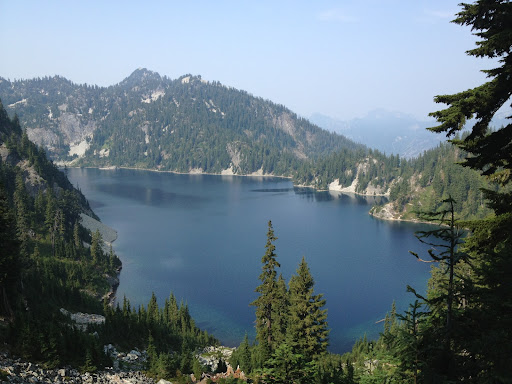
First sight of Snow Lake

Standing at the base of the lake

Rachel and me at the base of Snow Lake

The clarity of the lake

Hiking around to the far side of the lake where Rachel thought it looked like we might see a goat
Snow Lake waterfall
Day 2: Mount Si
4 miles from the trailhead at 850' to the peak at 3,900' for a round trip of 8 miles with a net climb of 3,150'.
Having spent the night in a tree house the night before, we had an early check out time so we were up early to hike Mount Si. This is one of those classic trails that I am sure every hiker from the PNW has done in their lifetime due to its proximity to Seattle, the short distance of the trail and the amazing views of the area from the top. Rachel was very excited about Mount Si as she had seen a Runners World Rave Run photo previous to our trip and wanted to experience it first hand. The climb to the top is pretty steady, gaining nearly 800' per mile but the trail is not overly technical. Toward the very top, the trail does steepen a bit before opening up to a view of some very large rocks. It isn't until you continue to climb again that you get a view of the Haystack. I tried to climb up the backside in 2009 but the scramble was too difficult and required climbing gear. After Rachel and I took some time to capture the moments in our mind, we ran back down in just over 42 minutes.
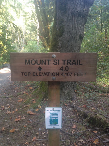
Trailhead signpost

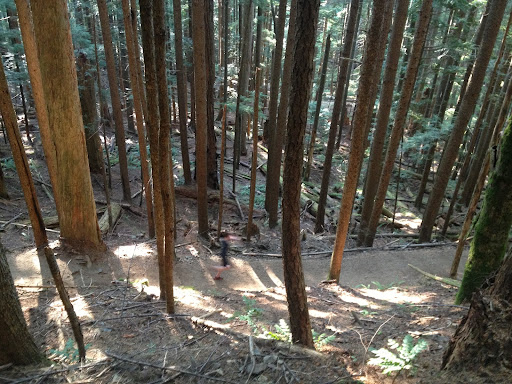
Lush green forest at the lower elevation

Amazing old growth forest with millions of fir trees

Trees so tall that it hurt my neck to look up that high

At the summit
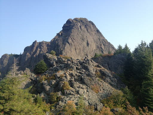
The top of the Haystack reaches 4,167'
Rachel and her Runners World Rave Run Moment
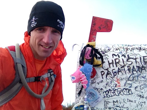
Day 3: Mailbox Peak
3 miles from the trailhead at 826' to the peak at 4,926' for a round trip of 6 miles with a net climb of 4,100'.
The first half mile of this route started from a blue gate at the edge of a parking lot and followed a gravel road to the trail head and climbed a moderate 300'. This meant that the remaining 3,800' of climb would be over 2.5 miles, or an average grade of 29%. I will admit that I really had no idea how steep that grade would be, to which I was stunned. The "trail" was not much of a "trail"; per the hiking guides I was following, it had noted that this "trail" was rough-hewn and mostly constructed by boots and use over time. Only recently had the hike to Mailbox Peak become recognized as an official trail and not just a crazy climb that a select few hikers had summited. Any pretense of switch backs was over after the first few minutes of climbing and from there it was basically straight up the side of the mountain. I was power hiking it as hard as I could with thoughts of making it in under an hour; for 3 miles! My heart was racing at 5km intensity and the calf burn was killing me. Finally I came to an opening where I could see a large boulder field that continued to climb, and luckily the trail would around the side to the left. Passing around the boulder field, I began the final section which was a combination scramble/hand-climb to the peak. The lack of rain left the trail very dusty and would pose problems of slipping and sliding on the way back down. Finally after 1 hour, 6 minutes and 2 seconds, I had made it to the top and placed a hand on the mailbox. There were a few guys on the peak hanging out eating sandwiches, celebrating their accomplishment. I have no idea what the record for the climb is, but I don't imagine its much faster than an hour; even the best of the best climbers still battle the shear climb of Mailbox Peak. I hung out on top and enjoy the sunshine, but the clouds blocked most of the view from nearby mountains. Within minutes the weather shifted dramatically and it became white out conditions and the temperature dropped. I put on my jacket and winter hat for the return trip to keep warm. Coming back down was painful on the quads and if I wasn't sliding on the rocks, I was falling from tree to tree. I wondered on the way up why all of the small trees at shoulder height were smooth to the touch; then I realized on the way down that most people fall to the next tree, catch themselves and use the tree to hold onto until falling to the next tree. This was one of the hardest hikes that I have ever done, but one of the most rewarding as well.

The final rocky climb to the top after coming out of the dense forest

Where Mailbox Peak gets its name from

Everyone leaves something behind

GPS time and elevation

Clear skies across the valley when I first arrived

Clouds moving in quickly
Complete white out before I left

Clouds hiding the route back down
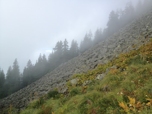
An example of the grade of the climb looking across the avalanche chute
Day 4: Mount Defiance
5 miles from the trail head at 2,200' to the peak at 5,584' for a round trip of 10 miles with a net climb of 3384' climb.
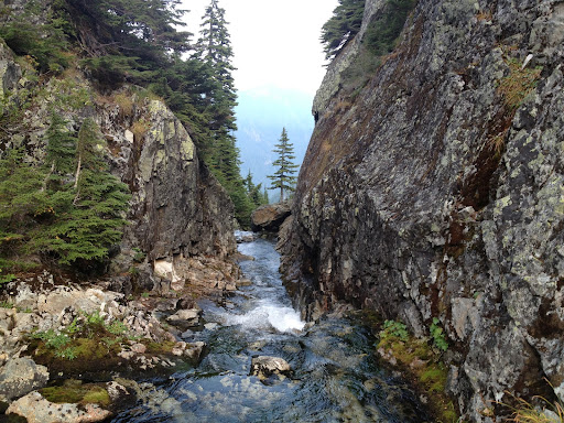
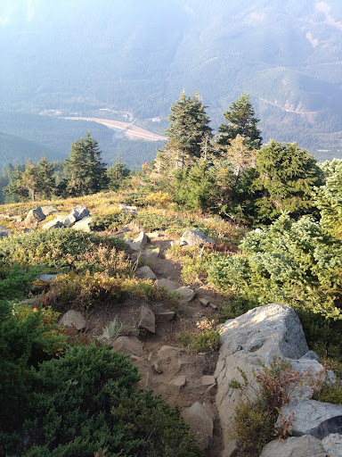
I wasn't sure what to expect with this trail and up until the last minute I was undecided between Mount Defiance and Granite Peak; the later maybe be a great climb but of all the hikes that we did in the Cascades, Mount Defiance was the gem! It had a little bit of everything; avalanche chutes, technical and nontechnical trails, plenty of climb, amazing views, waterfalls, grassy meadows, alpine lakes and old growth forests. From the start, the Ira Spring trail was fairly wide and steadily climbed from 2,200 up to 4,100' with some great sweeping views to the north. The first switchback was not until 3,500'. The higher the elevation, the more open the trail became and thus the views more breathtaking. At about 2.5 miles there was the split with the Bandera Mountain trail, with Mount Defiance to the north beyond Mason Lake and just after the first views of Mount Defiance were in the distance. I was a little confused after crossing into the Alpine Lakes Wilderness as the trail actually dropped down to Mason Lake. The glass-like lake provided some amazing reflective images that were just as impressive in person. After rounding the lake, the old growth forests with tall trees like at Mount Si were so much fun to run through before the grade started to increase again. When I thought I was near the top, the trail crossed the avalanche chute again and then opened up into a grassy meadow where the colors were all starting to change; it was so pretty! What I didn't realize was that there would be another 1/4 mile of scrambling on a rocky path to the top, but once I was there, it was clear that it was the summit. I made it to the top in 1:33:05. The views down to the highway that seemed days away, the sight of Mason Lake and Lake Kulla Kulla from 1000' above were so cool! I spent quite a bit of time at the summit just enjoying life before turning around. The return trip after the scramble section was all runnable down and I was able to come down much quicker.

Crossing the first avalanche chute
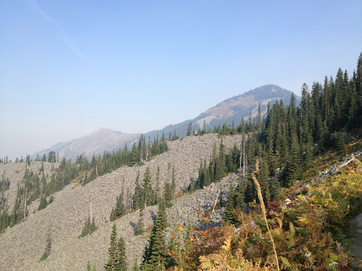
First view of Mount Defiance, still 2,000' of climbing to go

First crest at the edge of the wilderness

Awesome mossy rocks at a switchback down to Mason Lake
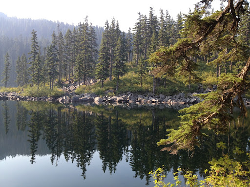
Reflections in Mason Lake
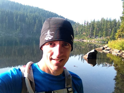
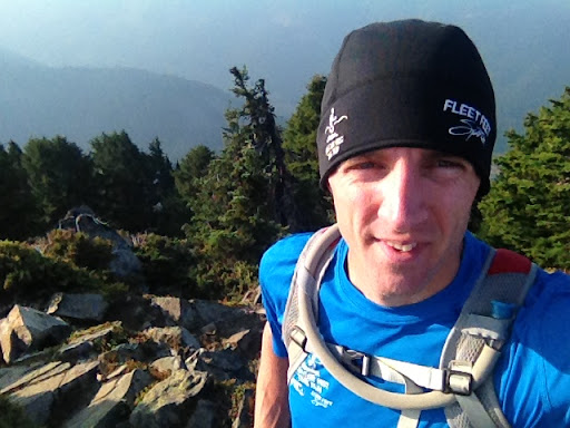
Self portrait at the lake

Old growth forest

Picturesque running conditions
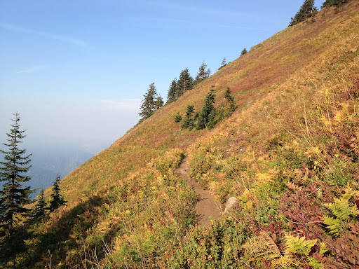
Crossing a grassy meadow at 5,000'
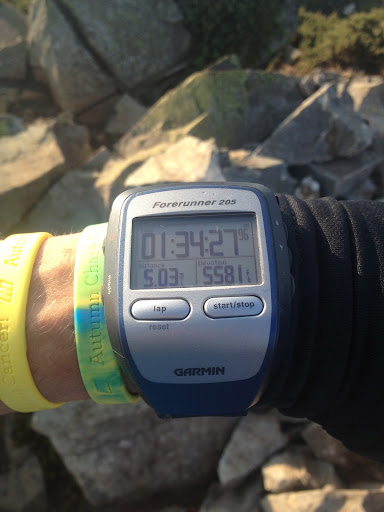
Time to the summit

The summit

Looking down over Lake Kula Kula a 1.000' below
So blessed to be able to reach such heights
Looking back down over the crest at the way back down